Location
The far northwest of Middle-earthRaces
Mainly populated by Men, especially after the establishment of Arnor, though Elves maintained a refuge at Rivendell and, after III 1601, the Shire in central Eriador became a populous land of the HobbitsSettlements
Numerous, with the most important being Annúminas and Fornost for Men, Rivendell for the Elves, and Michel Delving for the Shire-hobbits; the town of Bree lay near the centre of Eriador Source
Several important rivers rose in Eriador, including Baranduin, Bruinen, Lhûn and MitheithelImportant peaks
Bounded to the west by Ered Luin, the Blue Mountains, and to the east by the Misty MountainsPronunciation
eri'adorr ('rr' emphasises that the final r sound should be pronounced)
Meaning
'Lonely land'
Other names
The Lone-lands; closely equivalent to the Lands over West
Indexes:
About this entry:
- Updated 29 October 2008
- Updates planned: 1
|
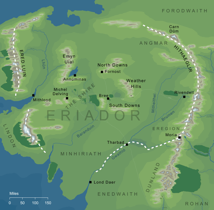
The geography of Eriador
The geography of Eriador
The Elvish name of the region called the Lone-lands in The Hobbit, the western lands of Middle-earth that lay between the Misty Mountains and the Blue.
See also...
Ambaróna, Angmar, Annatar, Aragorn I, Arahad I, Arahad II, Arvegil, Battle of the Gwathló, Bëorians, Bilberry, Bill, Black Years, Bree, Bridge of Mitheithel, Bridge of Stonebows, [See the full list...]Celepharn, Chieftain of the Dúnedain, Chieftain of the North, Ciryatur, Dark Lord, Days of Dearth, Days of Flight, Dís, Downlands, Dunlendings, Durin’s Bane, East End, East Road, East-West Road, Elendil, Elrond, Elu Thingol, Elven-rings, Elves of Eregion, Elves of Lindon, Ered Lindon, Ered Luin, Fallohides, Fell Winter of the Third Age, First House of the Edain, Fords of Isen, Forsaken Inn, Galadriel, Gap of Calenardhon, Gates of Moria, Gladden River, Great East Road, Great Road, Green-elves, Greenway-crossing, Guild of Weaponsmiths, Harfoots, Hobbits, House of the Mírdain, King of Arthedain, King of Durin’s Folk, Kingdom of the North, Kingdoms of the Dúnedain, Lady of the Noldor, Land of Caranthir, Last Homely House, Lenwë, Lond Daer Enedh, Lone-lands, Long Winter, Lord of the Black Land, Lord of the Earth, Malvegil, Mariner-king, Men of Darkness, Men of Eriador, Men of the Sea, Midgewater Marshes, Minhiriath, Mírdain, Misty Mountains, Mordor, Mountains of Angmar, Mountains of Lune, Noldor of Eregion, North-South Road, Old Road, Old South Road, Orcs of the Misty Mountains, Ost-in-Edhil, People of the Jewel-smiths, Redhorn Gate, Rhudaur, Ring of Sapphire, River Baranduin, River Hoarwell, River Loudwater, Sauron, Second Age, South Downs, South-gate of Bree, Stoors, Tar-Ciryatan, Tar-Minastir, Tar-Telperiën, The Angle, The Singers, The Towers, Three Keepers, Three Rings, Trollshaws, Two Kingdoms, Vice-regent of Eriador, Vilya, War of the Elves and Sauron, Weather Hills, Weathertop, West of Middle-earth, Western Mountains, Westlands of Middle-earth, White Mountains, White Towers, White Wolves, Wild Men
Indexes:
About this entry:
- Updated 29 October 2008
- Updates planned: 1
For acknowledgements and references, see the Disclaimer & Bibliography page.
Original content © copyright Mark Fisher 1997-2000, 2008. All rights reserved. For conditions of reuse, see the Site FAQ.
|