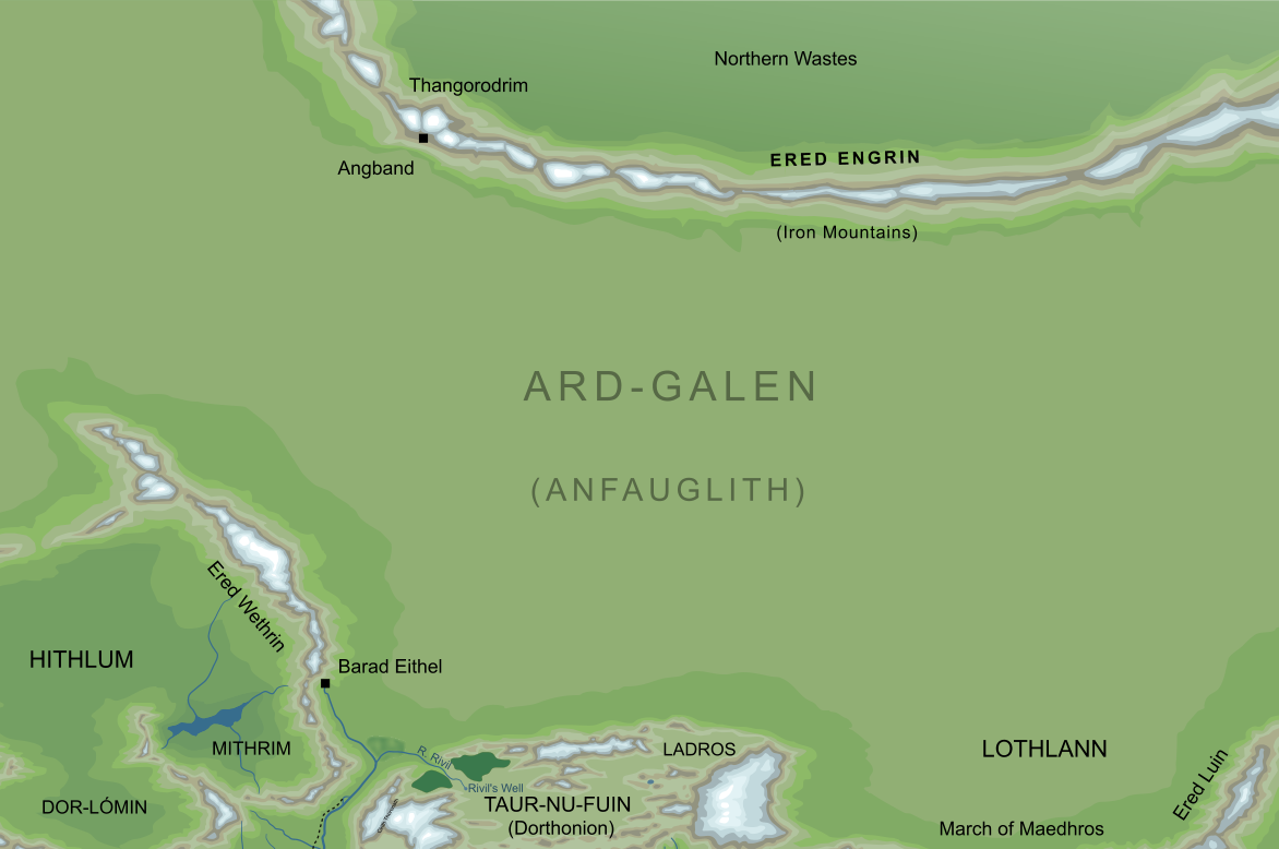
The western arc of Ered Engrin, the
Iron Mountains (somewhat conjectural)
1
The western arc of Ered Engrin, the
Iron Mountains (somewhat conjectural)
1In very ancient times, Melkor held Middle-earth under his sway from a vast citadel in the far North named Utumno. To protect this stronghold against the Valar, he raised a chain of mountains. These ran across the entire continent of Middle-earth, forming a long curve on the fringes of the northern ices, and stretching from the far west into the far east. These were the mountains of Ered Engrin, from the Elvish for 'Iron Mountains' or 'Mountains of Iron'.
When tested, the mountains of Ered Engrin proved little defence against the Valar. Roused to protect the Elves, who had recently awakened in Middle-earth, the Valar went to war against Melkor in Middle-earth. They broke through to Utumno and shattered its defences, capturing and imprisoning the Dark Lord. According to some tales, parts of the mountains of Ered Engrin were broken in this Battle of the Powers, and at the western end they became a shattered jumble of ranges that would later be known as Ered Wethrin and Ered Lómin.2
There followed long ages of peace in Middle-earth under the light of the stars, but at last Melkor was released from his imprisonment and, turning against the Valar, escaped back into Middle-earth. At the western end of Ered Engrin was an old outlying fortress of Utumno named Angband, which Melkor took as his new refuge. Angband lay northward of the Iron Mountains, and Melkor tunnelled beneath the peaks to create a way out onto the southward plains beyond. Above the southern Gate of this tunnel, the Dark Lord extended the heights of Ered Engrin, and raised them up to create a cliff-face said to rise for a thousand feet, breaking into three hideous and jagged peaks named Thangorodrim. At this time, it seems, the Great Eagles of Thorondor nested among the inaccessible heights of Ered Engrin to watch over their Enemy below.
As Melkor had escaped from Valinor, he had slain Finwë of the Noldor and stolen the Silmarils, and so Finwë's son Fëanor led his people in pursuit of the Dark Lord. As the newly-returned Noldor camped in the north of Middle-earth, close to his realm of Angband, Melkor caused noxious vapours to emerge from the mountains of Ered Engrin. The Noldor survived that assault, but during their early wars against Melkor (whom they named Morgoth), Fëanor's son Maedhros was captured and hung from the dreadful precipice of Thangorodrim. With the aid of Thorondor, Maedhros was rescued from his ordeal by Fingon.
Morgoth continued to skirmish against the Noldor over the decades that followed, until a time when the Dark Lord launched a great assault against the Elves. Once again he caused Ered Engrin to belch toxic fumes, and fire emerged from the mountains as great armies of Orcs swept across the plain of Ard-galen. The Orcs attacked the Elves in both the west and the east, but were driven back and decimated on both fronts. This was a great victory for the Elves, which they named Dagor Aglareb, the Glorious Battle. Nonetheless, they saw that Morgoth still had the power to deal them great harm, and they set up the Siege of Angband that would hold the Dark Lord at bay for nearly four hundred years. Nonetheless, the impassable arc of Ered Engrin prevented the Elves from fully besieging Angband, and the servants of Morgoth would depart at times by secret paths northward of the mountains and find their way over Ered Engrin into the lands of Beleriand beyond.
In the year I 455, after 395 years of the Siege of Angband, Morgoth broke the leaguer of the Elves. Once again he caused flames and poisons to emerge from Ered Engrin, this time with far greater force than before. The fires of the mountains ran out across the green plain of Ard-galen, burning it to ash and creating in its place the desert of Anfauglith. Out of the devastation came Glaurung the Dragon, with a train of Balrogs and uncountable Orcs. The defences of the Elves and their allies were swept away, and after this time the forces of Morgoth gradually advanced across the lands of Beleriand. Victories for the Elves were rare indeed after this disaster, though on one occasion, seven years after the Battle of Sudden Flame, the Noldor drove back an army of Orcs and pursued them as far northward as the valleys of Ered Engrin.
Over the next century, the Orcs of Morgoth marched far southward from Ered Engrin, to the point where their master's victory seemed assured. Morgoth had not foreseen, however, the intervention of the Valar from beyond the Sea. Their forces emerged out of the West and fought the terrible War of Wrath, breaking Angband and casting Morgoth out of the world into the Void. In that War, the lands westward of Ered Luin were devastated, and the remnants of Ered Engrin were sunk beneath the Great Sea.3
Notes
1 |
We have little detailed information about the geography of Ered Engrin, except that they formed an arc to the north in this western part of the range. This somewhat speculative map shows their approximate relations to the lands to the immediate south. For a less detailed map showing the entire range, see the entry for Iron Mountains.
|
2 |
These were the mountain ranges that lay around and within the land of Hithlum. The account of their being formed in the breaking of the western Ered Engrin appears in the older Quenta Silmarillion in volume V of The History of Middle-earth, but is not repeated in the published Silmarillion, and may not have been meant to stand.
It is clear that Tolkien's vision of the geography of Ered Engrin changed over time. A notable example is the map labelled 'Sheet 2' in volume XI of The History of Middle-earth, which shows Angband surrounded by a circular ring of mountains, and with no sign of the great curving range described in other sources. This ring perhaps represents a reimagining of the Ered Engrin (they are not labelled on the map), or perhaps the main range ran northward of the region shown. In either case, this representation is at odds with the descriptions given in various versions of Quenta Silmarillion, including the published form.
|
3 |
At least, the western end of Ered Engrin were lost at this time. If the range extended all the way across to the farthest eastern shores of Middle-earth, then presumably some more distant parts of Ered Engrin survived into the Second Age and beyond.
Indeed, we might speculate that part of those surviving mountains could still be seen in later Ages. The northern range known as Ered Mithrin, the Grey Mountains, showed a distinct east-west orientation, and lay on the edge of the northern ice, so we might speculate that this range represented a remnant of the ancient Ered Engrin (though it should be noted that no such connection is directly suggested by Tolkien himself).
|
Indexes:
About this entry:
- Updated 23 October 2022
- This entry is complete
For acknowledgements and references, see the Disclaimer & Bibliography page.
Original content © copyright Mark Fisher 1998, 2001, 2013, 2015, 2022. All rights reserved. For conditions of reuse, see the Site FAQ.
Website services kindly sponsored by Axiom Discovery aptitude and skill testing.
Axiom Discovery gives you comprehensive online aptitude testing covering core skills across a wide range of disciplines.