Tolkien's original conception of the
Inland Sea of Helcar
2
Tolkien's original conception of the
Inland Sea of Helcar
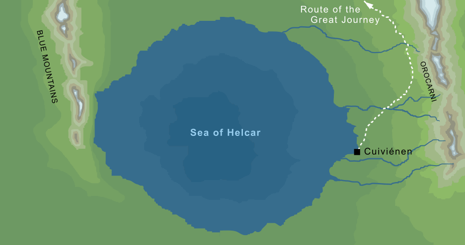
2A large inland sea in the east of ancient Middle-earth, roughly elliptical in shape. On its eastern shoreline lay the mountains of the Orocarni, and at their feet on a small bay was the land Cuiviénen, where the first Elves awoke in Middle-earth. It was there that Oromë discovered them, and ultimately led many of them on a Great Journey around the northern end of the Sea of Helcar as they set out for Valinor in the distant west.
Notes
1 |
The only maps to show Helcar are early ones, and they tend to place it rather nearer the centre of the world than to the north. However, the text of The Silmarillion states that '...that sea stood where aforetime the roots of the mountain of Illuin had been...' (Quenta Silmarillion 3), and that Illuin was raised '...near to the north of Middle-earth' (ibid 1), so Tolkien's conception seems to have changed over time. Interestingly, though it isn't mentioned in The Silmarillion, there seems to have been a corresponding southern sea, the Sea of Ringil, which was perhaps associated with the roots of Illuin's mate Ormal. |
2 |
The map shown here is based on an early sketch reproduced in volume IV of The History of Middle-earth, the only map we have that shows Helcar in any detail. At this early stage Tolkien saw the Blue Mountains as an immense range running from the far north down to meet the Sea of Helcar, but that seems inconsistent with later maps, which show this range much reduced in size.
In fact, no map exists of the Blue Mountains in the First Age that shows their southern end, so in principle they could have continued far into the south as shown on this early map. However, we do know that they were a relatively short range in the Second and Third Ages. Perhaps these far southern reaches of Ered Luin did exist at some time, but were later destroyed in the battles between the Valar and Melkor, conceivably in the cataclysmic War of Wrath that ended the First Age.
|
Indexes:
About this entry:
- Updated 16 October 2008
- This entry is complete
For acknowledgements and references, see the Disclaimer & Bibliography page.
Original content © copyright Mark Fisher 1998, 2001-2002, 2007-2008. All rights reserved. For conditions of reuse, see the Site FAQ.