Location
The western borders of Eriador, where it marched with LindonRace
Particularly associated with DwarvesDivisions
Various, but in the Third Age the mountains were occupied by the Longbeards ( Durin's Folk) Cultures
Family
Settlements
Belegost and Nogrod (destroyed at the end of the First Age); the halls of Durin's Folk were established in the mountains in the later Third Age
Sources
Several rivers rose in the mountains, of which only the Lune (via its tributary the Little Lune) is named Outflows
Rivers from these mountains flowed into the Gulf of LhûnImportant peaks
Meaning
Uncertain1
Other names
Indexes:
About this entry:
- Updated 14 July 2013
- Updates planned: 1
|
Blue Mountains
The northwestern mountain-chain of Middle-earth
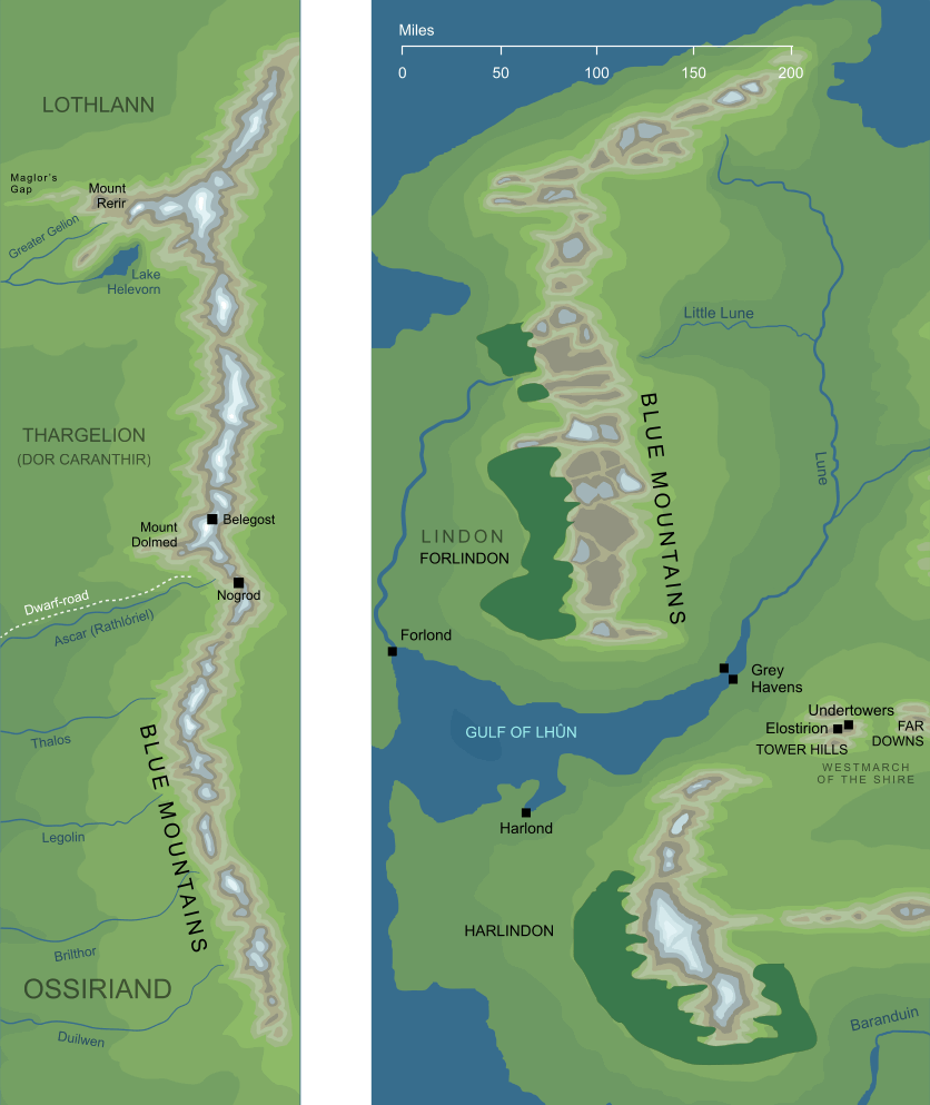
The map on the left shows the Blue Mountains during the First Age, before the cataclysm that brought that Age to its end. The map on the right shows the later geography of the mountains, specifically in the early years of the Fourth Age.
The map on the left shows the Blue Mountains during the First Age, before the cataclysm that brought that Age to its end. The map on the right shows the later geography of the mountains, specifically in the early years of the Fourth Age. The Ered Luin, the mountain chain that formed the eastern border of the lands of Beleriand during the First Age, and in which were the Dwarf-cities of Nogrod and Belegost. After the loss of Beleriand at the end of the First Age, the mountains remained, but they were now in the far west of Middle-earth.
Notes
1 |
It would be natural to assume that the Blue Mountains gained their name simply because they appeared blue in colour, and this may well be the case. There is reason to think, however, that the name may have had a deeper - if somewhat mysterious - significance. On old sketch-maps from volume IV of The History of Middle-earth, we see Tolkien's original ideas for the geography of Arda. In particular, Map IV from that source shows Middle-earth in its original structure, showing it as far more symmetrical than it later became. In that scheme, the continent has four long mountain-chains: the Blue Mountains to the northwest, the Red Mountains (or Orocarni) to the northeast, the Grey Mountains to the southwest and the Yellow Mountains to the southeast. (The Grey Mountains here, incidentally, had no connection with the northern Grey Mountains of later conceptions.) This highly structured layout implies that the colours of the different mountain ranges carried some kind of deeper meaning, though we're given no indication of what that meaning might have been. |
See also...
Aeglos, Alders, Amlach, Aradan, Arnor, Atanatári, Awakening of Men, Azanulbizar, Balin, Balrogs, Belegost, Bëor, Bëorians, Bilbo Baggins, Borlad, [See the full list...]Boron, Borthand, Child of the Twilight, Círdan the Shipwright, Dark Elves, Dark Lord, Denethor, Dís, Dor Caranthir, Durin’s House, Dwarf-cities, Dwarf-kind, Dwarf-road, Dwarves, Dwarves of Belegost, Dwarves of the Blue Mountains, East End, East Vale, East-elves, Edain, Eglador, Elu Thingol, Elvenesse, Elves of Beleriand, Elves of Harlindon, Elves of Lindon, Elves of Ossiriand, Eöl, Ered Lindon, Ered Luin, Ereinion Gil-galad, Eriador, Estolad, Falmari, Ferns, First House of the Edain, Firth of Lune, Folk of the Mountain, Ford of Stones, Forlindon, Forsaken Elves, Friend-of-Men, Gabilgathol, Galadriel, Glóin, Goldenbed, Gonnhirrim, Great East Road, Great Lands, Great Road, Great Sea of the West, Greater Gelion, Green-elves, Haladin, Haldad, Hathol, Hollowbold, Icebay of Forochel, Khazad-dûm, Kíli, King of Durin’s Folk, King of the Elves, King under the Mountain, Lady of the Noldor, Ladybarrow, Laiquendi, Lake Helevorn, Land of Caranthir, Land of Seven Rivers, Land of the Elves, Lenwë, Lindon, Little Lune, Lone-lands, Longbeards, Lord of Belegost, Lord of Nogrod, Lord of the Dark, Lord of the Earth, Lord of the Havens, Maglor’s Gap, Masters of Stone, Men of Darkness, Men of Dorthonion, Men of Eriador, Men of Hithlum, Men of the North-west, Men of the Three Houses, Menegroth, Mickleburg, Middle Men, Middle Peoples, Mírdain, Misty Mountains, Mount Rerir, Mountain Kingdom, Mountains of Lune, Mountains of the East, Mr. Lucky Number, Nandorin, Necklace of the Dwarves, Nogrod, Nóm, Nómin, Nori, Northern Lands, Old Ent, Orcs of the Misty Mountains, Ossiriand, People of Bëor, People of Hador, Ring of Durin, River Anduin, River Ascar, River Baranduin, River Brilthor, River Duilwen, River Legolin, River Lhûn, River Thalos, Ruin of Beleriand, Runes of Doriath, Sarn Athrad, Sea-kings, Second Age, Seven Rivers of Ossir, Shadow of Morgoth, Sindar, Sindar of Beleriand, Sons of Fëanor, Swarthy Men, Telchar, Thain of the Shire, Thargelion, The Accursed, The East, The Easterling, The Encampment, The Minstrel, The Old, The Wise, Third House of the Edain, Three Houses of the Edain, Three Houses of the Elf-friends, Tumunzahar, Tyrn Gorthad, Ulfast, Vales of Anduin, Vassal, Vice-regent of Eriador, West of Middle-earth, West-shores, Western Mountains, Wide World, Wild Elves, Wild Men, Wise People, Younger Children of Ilúvatar
Indexes:
About this entry:
- Updated 14 July 2013
- Updates planned: 1
For acknowledgements and references, see the Disclaimer & Bibliography page.
Original content © copyright Mark Fisher 1999, 2001, 2013. All rights reserved. For conditions of reuse, see the Site FAQ.
|