As any reader of The Lord of the Rings will know, that book contains a whole range of maps showing the lands of Middle-earth during the last years of the Third Age. Readers of the The Silmarillion will know, too, that that book provides a map of Beleriand during the First Age. Judging by the contents of our e-mail inbox, there does seem to be quite a lot of confusion about how these two maps fit together: confusion that this FAQ entry will attempt to dispel!
The key to understanding how the maps relate to one another is in the text of The Silmarillion itself, and particularly in the story of the War of Wrath. That's the Great Battle at the end of the First Age, in which the Valar sent an overwhelming force to Middle-earth to defeat Morgoth. This 'war of the gods' left Beleriand devastated: '...so great was the fury of those adversaries that the northern regions of the western world were rent asunder, and the sea roared in through many chasms...' (Quenta Silmarillion 24). That's the reason why the First Age map from The Silmarillion doesn't fit with the Third Age maps from The Lord of the Rings: the lands shown on the earlier map were drowned by the Sea at the end of the First Age. (It should be said that some sources suggest that this drowning was a two-stage process, with Beleriand being greatly changed at the end of the First Age, and then completely drowned after the Downfall of Númenor in the Second - however this might be, the effect would be the same at the end of the Third Age).
A few remnants of the earlier landscape survived, and those can be made out on the maps in The Lord of the Rings. The most obvious is the mountain range known as Ered Luin, or the Blue Mountains. In the First Age, they formed a continuous eastern border to Beleriand, far from the Sea (they're shown along the eastern edge of the Silmarillion map). In the Third Age, the Sea comes almost to their foothills, and has rushed through in one place to form a wide gulf (the Gulf of Lhûn). West of the mountains is the land of the Elves known as Lindon. In the First Age, this was an inland region (more commonly called Ossiriand), but in the Third it formed a new shoreline, and a narrow land between the Mountains and the Sea. The only other remnant of the First Age shown on the maps within The Lord of the Rings is the island of Himling, off the northwestern coasts of Middle-earth. In the First Age, this had been the Hill of Himring, where Maedhros son of Fëanor had his fortress. Apart from its historical interest, it's also important as a point of reference between the two maps, allowing us to work out exactly how the coastlines of the First and Third Ages fitted together.
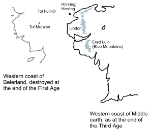
We know that other places survived the inundation, too. For example, The Silmarillion states that the Stone of the Hapless, the memorial to Morwen, Túrin and Nienor, survived to become an island, The location of that island - Tol Morwen - is shown on the map above. In his introduction to Unfinished Tales, Christopher Tolkien also notes the existence of a larger island, Tol Fuin, the remnant of the earlier highlands of Taur-nu-Fuin. These islands survived the cataclysm at the end of the First Age, but another, the Isle of Meneltarma, had a much later origin - it was the peak of the Meneltarma, the central mountain that was the only part of Númenor to survive its Downfall in the late Second Age. The Isle of Meneltarma isn't shown on the map above: it would lie far off to the west.
As for the remains of Gondolin, or Nargothrond, or Menegroth, or any of the other great cities and fortresses of the First Age, they were lost, either being destroyed in the War of Wrath itself, or drowned by the inrushing Sea. We don't have any precise details of their fates, but if anything of them survived the War, and lasted through thousands of years beneath the ocean, they would have been nothing more than crumbling undersea ruins at the end of the Third Age.
For acknowledgements and references, see the Disclaimer & Bibliography page.
Original content © copyright Mark Fisher 1997-2025. All rights reserved. For conditions of reuse, see the Site FAQ.
Generate DISC results instantly and automatically, and receive an alert as soon as those results are available.